Inner Mongolia Water Resources Department purchases vegetation cover measuring instrument
In November 2016, the Inner Mongolia Water Resources Department purchased the vegetation cover measuring instrument, which has been shipped and won praise from users!!
Vegetation coverage photogrammetry / vegetation measuring instrument
product description:
Vegetation coverage photogrammetry/vegetation measuring instrument includes two parts: portable vegetation coverage photogrammetry instrument and surface vegetation coverage automatic calculation system: one of them is the hardware part, that is, portable vegetation coverage photogrammetry instrument, its function is to carry out Vertical photography to obtain vegetation coverage images; the other is the supporting software part, PCOVER software, whose function is to process the acquired images and automatically calculate the vegetation coverage.
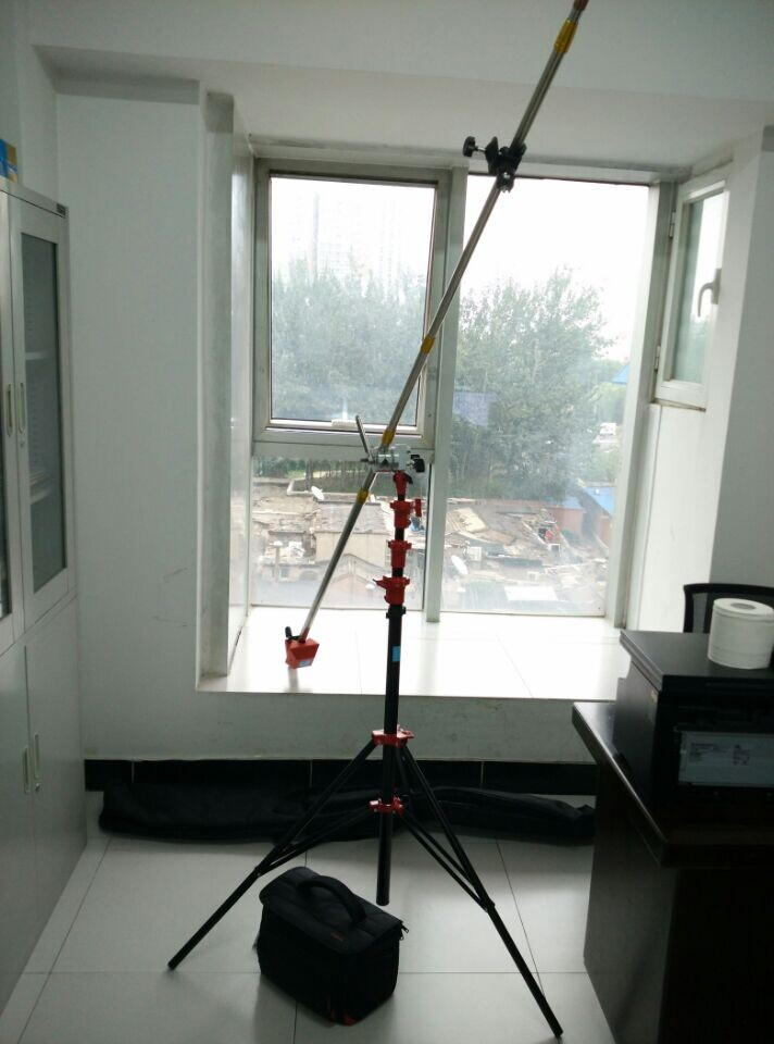
I. Vegetation coverage photogrammetry instrument / vegetation measuring instrument
In order to take vertical photographs of surface vegetation and obtain vegetation cover information, the camera must be raised to a certain height from the surface and have good stability. This operation must be carried out with certain equipment and equipment. At the same time, the device is required to be light, portable and easy to operate. The portable vegetation coverage photogrammetry instrument is designed and manufactured according to this requirement.
Introduction: A portable vegetation coverage photogrammetry instrument that performs vertical down-camera measurements in the field. The three adjustable legs of the triangular bracket are respectively fixed and fixed on the ground, the column is inserted into the leg seat plate in the center of the triangular bracket, the tightener and the long cymbal locker are fixed on the column, and the long cymbal is inserted into the long cymbal locker. The camera is placed in the camera case with the lens facing down, and the camera case is fixed at the end of the long end. The pull wire of the wire tightener is connected to the long cymbal ring fixed on the long cymbal through the wire guide ring, and the hand is tightly tightened. The device tightens the puller wire and straightens the long tail of the suspended camera. The height of the camera suspended from the end of the long raft is adjusted by the number of round rods forming the long pole, the length and angle of the adjustable leg of the triangular bracket, and the length of the column. The person controls the ground through the remote control. A camera suspended at the end of the long rod performs a vertical downward photographic measurement of the surface vegetation cover.
2. Vegetation coverage photogrammetry instrument/vegetation measurement instrument Vegetation coverage automatic calculation system is a software specially developed for portable vegetation coverage camera. The purpose is to process the vegetation image obtained by it and automatically calculate it through the model. Vegetation coverage. The operating environment is Windows 2000 or Windows XP. The system installation requires about 30M hard disk space.
The function mainly includes two parts: one is image preprocessing, including image browsing, image enlargement and reduction, image rotation, image window cutting, image format conversion, etc., in preparation for calculating vegetation coverage from images; Degree calculation and its central projection correction. For the preprocessed vegetation image, the automatic interpretation model is used to calculate the vegetation coverage, and the error of the center projection is corrected, and the final vegetation coverage of the image is obtained.
Three: Vegetation coverage photogrammetry / vegetation measuring instrument technical indicators:
Specifications: Weight: 7.2Kg (including counterweight)
Size: Vertical: 2.0 meters
Landscape: 5.4 meters shooting
Height: 0-6.4 meters
Vertical load: 100Kg
Lateral load: 15Kg
Winch load: 20Kg
Level adjustment range: 360°
Vertical adjustment range: 0--75°
Remote shooting distance: 5 meters
Shooting pixels: 14.1 million
Four: Introduction to instrument function:
1. Simultaneous analysis of multiple or one color, accurate data.
2. Picture cropping, zooming out, zooming in, panning, full-duty mode
3. Single image calculation coverage and batch processing two modes
4. Generate black and white dichroic maps and color contrast maps to make calculations more accurate, more versatile and more intuitive.
5. Save the calculation results (Excel format), all data can be traced, and the average is automatically obtained.
6. You can directly connect to the camera or camera to take photos, take photos continuously, and the data can be obtained in real time. You can also take pictures first, then analyze, and separate inside and outside.
7. The whole system adopts professional equipment, which is easy to install and carry.
Five: basic configuration list:
1. Strut (5m or 9m with ground) (standard)
2. Universal turning head (standard)
3. Digital camera (standard, optional infrared camera)
4. Remote control digital camera shooting terminal (smartphone or tablet)
5. Coverage calculation software (standard)
6. Notebook (optional)
Ningbo XISXI E-commerce Co., Ltd , https://www.petspetstoys.com